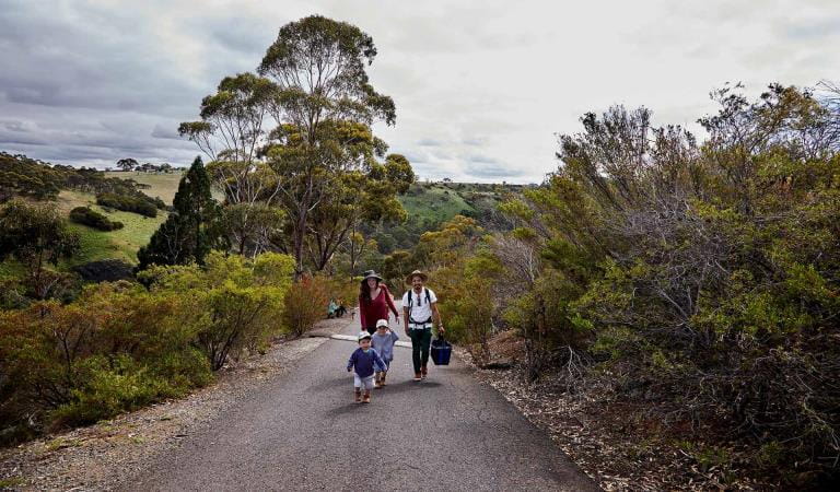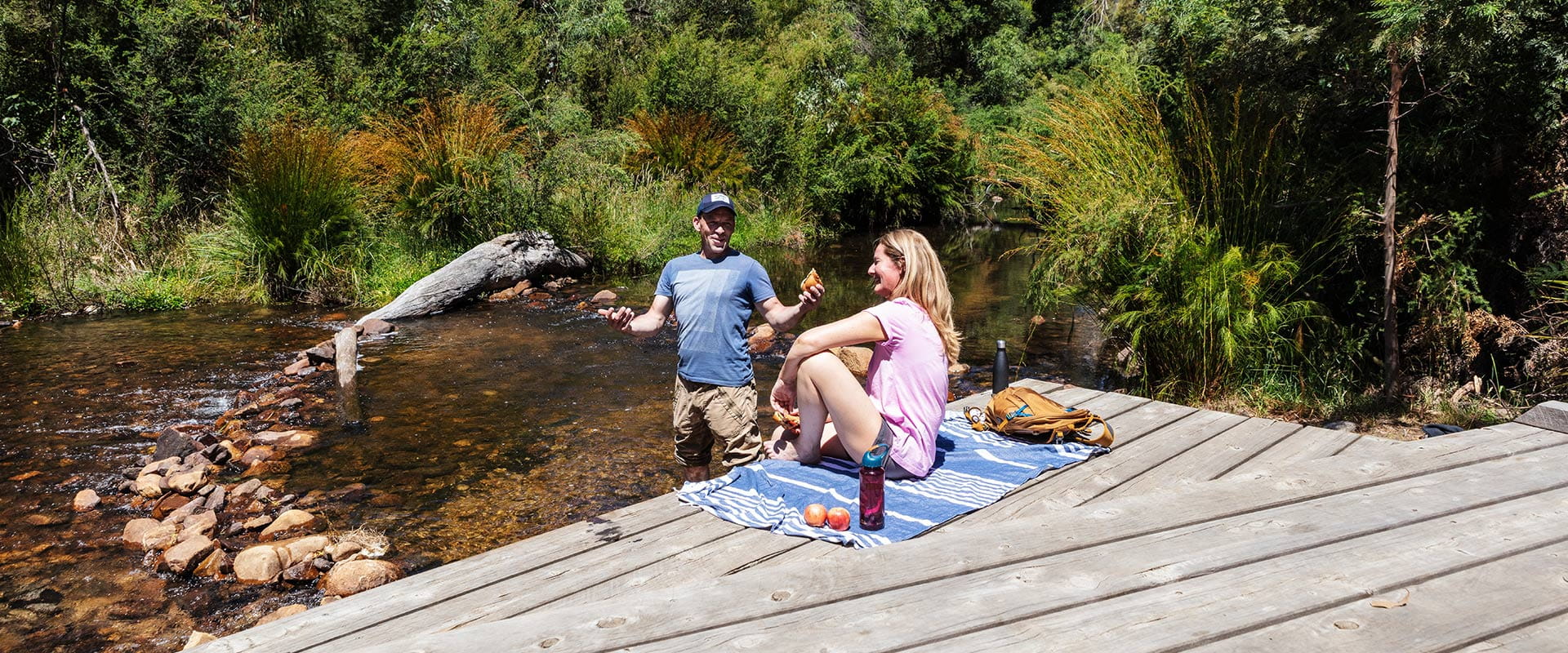
Zumsteins Historic Area is one of the best picnic spots for your day trip in the central Grampians. Enjoy a picnic or barbecue in scenic surrounds nestled near the banks of the MacKenzie River.
Discover the history of Zumsteins as you follow interpretive signs through the settlement. See remnants of cottages built in the 1930s as part of an old retreat for holidaymakers.
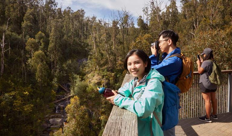
Follow the boardwalk along the banks of MacKenzie River. Watch the tranquil water and see if you can spot a platypus swim by.
Zumsteins Picnic Area has disabled access toilets, compacted gravel paths, electric barbecues and picnic shelters. A timber boardwalk is located along the banks of the MacKenzie River to allow visitors to interact with the river. It is suitable for wheelchairs.
Things to do
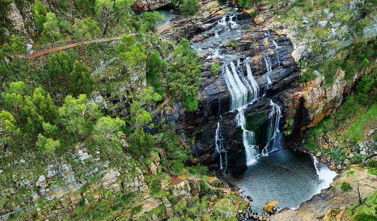
MacKenzie Falls
Picnics
Day trips
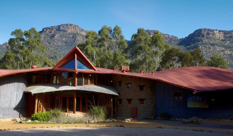
Brambuk The National Park and Culture Centre
How to get there
Zumsteins Historic Area
When you're there
Need to know
Zumsteins Historic Area
Accessibility
Visiting a park can be more of a challenge for people with disabilities, however in Victoria there are a wide range of facilities to help people of all abilities enjoy our wonderful parks around the state.
Assistance dogs are welcome in Parks Victoria parks and reserves. Entry requirements apply for parks and reserves that are usually dog prohibited, such as national parks.
Change of Conditions
Nature being nature, sometimes conditions can change at short notice. It’s a good idea to check this page ahead of your visit for any updates.
-
Notices Affecting Multiple Sites
Temporary Closure Notification – Planned Burn – Millstream Creek
FFMVIC have scheduled ignition for the following Planned Burn within Grampians (Gariwerd) National ParkMillstream Creek (GR-WIM-HGP-0081)This burn is located 6km west of Halls Gap.Start Date: Tuesday May 7, 2024End Date: Tuesday May 14, 2024Ignition is scheduled from Tuesday May 7, 2024For visitor safety and to allow FFMVIC staff to prepare and deliver the burn, temporary closures on roads/tracks, visitor sites and walking tracks will be in place. These will re-open when the burn, or specific areas of the burn are declared safe.· Smiths Mill Campground· Mackenzie Falls carpark· Mackenzie Falls Lookout Walk· Mackenzie Falls Walk· Zumsteins picnic area· Fish Falls and Mackenzie River· Boroka Lookout· Boroka Walking Track· Reed Lookout· The Balconies Lookout· Lake Wartook· Lake Wartook Lookout CarparkOperational Road closures from Tuesday 7th of May until at least Friday 10th of May:· Mt Victory Road from Zumsteins Picnic Area to Glenelg River Road· Wartook Road· Mt Difficult Rd from the Wartook Reservoir Wall to Mt Victory Rd including Boroka Lookout· Old Mill Rd· Ricky Track North and Rose Creek Road· Longpoint Fireline WestWill this burn impact the Grampians Peaks Trail experience? (Sections N3 & N4)No vehicle access to Mt Difficult Rd parking sites for walks into Gar and Werdug Hike-in Campgrounds. Grampians Peaks Trail (N3/N4) remains open through to Halls Gap. Stay informed about the Autumn planned burns schedule:Visit & Sign Up: Sign up to Planned Burns Victoria www.vic.gov.au/plannedburns Set up automated notifications about upcoming planned burns on public land near you. There is no charge to sign up to receive text messages.Download: The Vic Emergency App. Set up a watch zone and choose to be notified about planned burns in the ‘alerts’ settingsCall: The Vic Emergency Hotline on 1800 226 226 and request an interpreter or assistance for hearing difficulties via the National Relay Service. IN AN EMERGENCY CALL 000Email: For specialist advice about planned burns in the Wimmera District you can contact Horsham FFMVic Office at wimmera.fuelmanagement@delwp.vic.gov.au or phone the office on (03) 8508 1222.For Information about park closures and campground bookings within Grampians (Gariwerd) National Park:Visit the Parks Victoria website: https://www.parks.vic.gov.au/places-to-see/parks/grampians-national-park#change-of-conditionsVisit Brambuk the National Park and Cultural Centre – 277 Grampians Road Halls Gap, Ph 8427 2058 or for bookings and cancellations advice contact the Parks Victoria Information Centre Ph 13 1963 or email info@parks.vic.gov.au
Grampians National Park - Autumn planned burn season underway
Grampians (Gariwerd) National Park – Autumn Planned Program UnderwayForest Fire Management Victoria (FFMVic) have commenced the Autumn Planned Burning Program in Grampians (Gariwerd) National Park and surrounding reserves.These planned burns have been nominated and approved as part of the FFMVic three-year Joint Fuel Management Program for the Wimmera Fire District. Each burn has been designated to a year and season, though this may change depending on burn objectives and seasonal conditions. You can view the three-year plan at https://www.ffm.vic.gov.au/bushfire-fuel-and-risk-management/joint-fuel-management-programThe map attached, outlines the burns programmed for this year. Detailing the exact date and time of ignition can be difficult and the final decision to proceed may only be made on the day of the burn - once resources, weather conditions and local fuel moisture levels are deemed suitable. Once a burn is scheduled for ignition, FFMVIC will send out regular notifications.Some of the planned burns this Autumn may involve the temporary closure of visitor sites, roads and campgrounds within Grampians Gariwerd National Park and other reserves. This may include detours or closures of hike in campgrounds along the Grampians Peaks Trail, and other vehicle-based campgrounds.· Closures will be enforced for the duration of ignition and may remain in place for some days. Visitor sites will re-open once the burn is declared safe.· We recommend that you seek information and stay informed about the status of the planned burns scheduled near you.Stay informed about this Autumns planned burns schedule:Visit & Sign Up:Sign up to Planned Burns Victoria to set up automated notifications about upcoming planned burns on public land near you. There is no charge to sign up to receive text messages.
Sign up via Planned Burns Victoria at www.vic.gov.au/plannedburnsDownload: the VicEmergency AppSet up a watch zone and choose to be notified about planned burns in the ‘alerts’ settingsCall: the VicEmergency Hotline on 1800 226 226 and request an interpreter or assistance for hearing difficulties via the National Relay ServiceEmail: For specialist advice about planned burns in the Wimmera District you can contact Horsham FFMVic Office at wimmera.fuelmanagement@delwp.vic.gov.au or phone the office on (03) 8508 1222.For Information about park closures and campground bookings within Grampians National Park:Visit the Parks Victoria website: https://www.parks.vic.gov.au/places-to-see/parks/grampians-national-park#change-of-conditionsVisit: Brambuk the National Park and Cultural Centre – 277 Grampians Road Halls Gap, Ph 8427 2058or for bookings and cancellations advice contact the Parks Victoria Information Centre Ph 13 1963 or email info@parks.vic.gov.au -
Grampians National Park
Mountain Lion (Designated rock-climbing and bouldering area) – Temporary exclusion
Mountain Lion (Designated rock-climbing and bouldering area) – Temporary exclusionSignificant Aboriginal cultural values have recently been rediscovered at the Mountain Lion designated rock-climbing and bouldering area.While Parks Victoria and Gariwerd Traditional Owners determine a longer-term management response, and out of respect for this significant cultural landscape, visitors are requested to not access this area.The Aboriginal Heritage Act 2006 protects Aboriginal cultural heritage and significant financial penalties apply for harm caused by individuals or corporate bodies.For more information please visit the FAQ Update at the Rock Climbing in Gariwerd link below.Grampians (Gariwerd) National Park - Bushfire Closures Update - April 26, 2024
Grampians (Gariwerd) National Park was impacted by the Bellfield and Stapylton bushfires from 13th February 2024. There are temporary closures still in place in the vicinity of the fires. Visitors are asked to adhere to road and park closures as we work to assess and re-open these areas.Northern Grampians (Mt Stapylton Fire) Closures remaining April 26, 2024:Road/track closures east of Mt Zero RoadGolton trackCrutes track/Crutes roadNo off-track walking within the burnt areaMt William Range (Bellfield Fire) - Closures remaining April 26, 2024Tunnel Walking TrackMt Cassell TrackPomonal FirelineBirdrock RdNo off-track walking within the burnt areaAll other areas of the Grampians (Gariwerd) National Park previously closed due to the fires have been re-opened.For further information about the closures, please visit Brambuk the National Park & Cultural Centre, or call (03) 8427 2258. For National Park Information visit www.parks.vic.gov.au, or for booking refunds email info@parks.vic.gov.auPlease visit www.emergency.vic.gov.au for emergency updates, or free call 1800 226 226. Monitor the Emergency Vic app for alerts and warnings or listen to your local ABC radio stations for emergency broadcasts.Mt Zero Road Closure – Mud Hut Creek bridge replacement – 7th May to July 2024
Mt Zero Road will be closed between Roses Gap Road and north of Heatherlie Quarry between the 7th of May and July 2024 while the Department of Environment Energy and Climate Action (DEECA) undertakes critical bridge replacement works approximately 100m south of Roses Gap Road.Visitors wishing to travel between Halls Gap, Roses Gap and the Northern Grampians area (Hollow Mountain, Mt Zero and Mt Stapylton) will need to follow a detour via Ledcourt and Lake Lonsdale areas. See attached map.Plantation Campground and Heatherlie Quarry are still accessible from Mt Zero Road south (Halls Gap) or Pines Road.For further information on national park access please contact Brambuk the National Park and Cultural Centre phone 8427 2058For bridge replacement project information email roadsandcrossings@delwp.vic.gov.auAttachments: Mud Hut Creek - Bridge Works 2024 (584KB)
Similar experiences
Masons Falls
Picnic areas in Brisbane Ranges National Park